Bulk earthmoving is seldom straightforward – especially when it takes place in wet conditions surrounded by sites of special scientific interest (SSSIs), archeological digs and vulnerable habitats. The task undertaken by joint venture contractor Team Van Oord at Medmerry, near Selsey in West Sussex, had all these complications – and more.
Team Van Oord, comprising Dutch contractor Van Oord and British contractors May Gurney and Mackley Construction, has the main contract for the Medmerry managed realignment project, a major sea defence scheme for the Environment Agency which, unlike traditional sea defences, is designed to allow the sea to encroach upon the land in a controlled way, rather than attempt to halt its progress.
This involves building new defences inland from the coast and allowing a new intertidal area to form seaward of these new defences. The project is calculated to offer 1,000 times better flood protection than the existing defences, and is designed to provide flood protection against rising sea levels over the next 100 years.
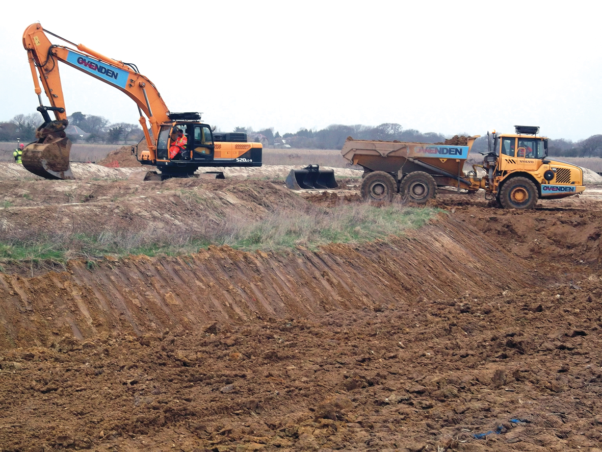
Above: Earthmoving contractor Ovenden spreads a layer of topsoil over the clay core.
The seaward area will create new intertidal and freshwater habitats to compensate for some of the habitat losses resulting from unrelated flood defence works around the Solent.
Located between Selsey and the village of Bracklesham, Medmerry is one of the stretches of coastline most at risk from flooding in southern England. As the Anglo-Saxon King Cnut is famously reputed to have demonstrated 1,000 years ago (just down the coast at Thorney Island) no human intervention can defy the sea for long and any attempt to prevent it encroaching on Medmerry would have been expensive and ultimately futile. Allowing the sea to flood the coast is the easy bit – simply a matter of breaching the shingle ridge and letting the tide flow in. The crucial element is managing the water and preventing its journey further inland. This has been achieved by building a 6.8km-long earth embankment designed to contain the flood within the intertidal area while blending into the surrounding landscape and allowing the drainage of inland watercourses, namely the drainage ditches and dykes known locally as “rifes”. This embankment comprises approximately 450,000m3 of material, all of it sourced from within the site itself, and consisting of a clay core with a height of 5.2m AOD. The undulation of the surrounding landscape means that this barrier is only 1m high in places. The material has been excavated from borrow-pits on the seaward side, explains Mackley’s Jacqui Bandy, public liaison officer for Team Van Oord. “These borrow pits had a dual purpose,” she explains. “Not only did we excavate the clay for the embankment from them, but they also form the basis of the intertidal habitat.”
The design of the embankment and the intertidal area was carried out jointly by Jacobs and Southampton-based coastal specialist ABP Marine Environment Research (ABPMER) with the former focusing on the civil engineering element and the latter designing the new habitat.
The whole area on both sides of the embankment has for centuries been a complex system of ditches and rifes and the challenge was to manage their drainage and realignment to ensure that the fresh and salt water, draining off the land and in from the sea, flowed in the right directions.

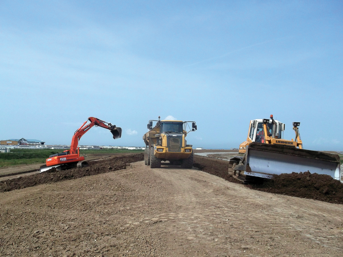
Above: All the materials used in the embankment was excavated from borrow pits on site.
Because of their other role as the basis of the intertidal habitat, the borrow-pits could not simply be plundered for the clay material, but had to be carefully excavated according to the design, with predetermined levels and slopes to ensure their suitability as natural landforms. “This was not just an engineering decision but also an ecological one” says Bandy. On top of the clay core, earthmoving subcontractor Ovenden carefully added layers of fertile material. “The outer layers vary across the site depending on the local distribution and consist of different materials including sand, shingle, topsoil and subsoil,” says Bandy. This has been planted with a variety of species appropriate to the location – topsoil seeded with meadow wildflower mix used along the inland face of the embankment and coarser sedges and rushes on more exposed areas.
“The embankment is part of the landscape and is designed to be entirely self-supporting,” she adds. “No additional material was required except for a small quantity of geotextile reinforcement at either end of the structure.” Co-ordination of the work was also crucial with the construction of the embankment having to keep up with the excavation and landscaping of the intertidal zone. “We tried not to stockpile clay because the material changes when exposed to air and allowed to dry,” says Bandy. “Also, we didn’t want to double-handle it.” Work on the embankment got underway in October 2011 with completion planned for early 2013. But despite careful human planning, nature once again conspired to delay progress.
“We wanted to be finished in the spring,” says Bandy, “but the wet weather in 2012 delayed us. We had such a wet summer that the whole site turned into a bog.”
The only way to access the full 6.8km of the embankment was over rough ground as there were no temporary roads for the plant and vehicles. “There’s no way we could have built haul roads to every part of the site,” explains Bandy. “We would have had to import so much material and then remove it from site afterwards – that’s a whole earthmoving project in itself.” The entire site is a SSSI and home to a wide variety of rare and endangered species, as Bandy explains: “There’s a large area of vegetated shingle, plus populations of great crested newts and a strong population of water voles.” The soft, wet conditions quickly made access difficult, particularly with the onset of winter. This not only hampered progress but also risked causing huge damage to the diverse and fragile habitats across the site. “The SSSI area included geological features such as a fossilised seabed. “We couldn’t track heavy machines backwards and forwards over these areas,” she says. “We did try out some tracked dumpers as a possible way of overcoming the poor site conditions. Even they didn’t work – they made such a mess,” adds Bandy.
The only option was to stop earthmoving altogether during the winter months, she explains. Where the embankment approaches the shoreline, the earth bund gives way first to transition stone and finally coarse rip-rap to absorb and disperse the force of the waves breaking over the shingle bar. Here, Team Van Oord used a geotextile membrane under the rock to provide a stable bed and reduce erosion. Around 60,000 tonnes of rock were brought in from Norway by barge which was anchored offshore while a fleet of smaller barges unloaded the material. The rock was stockpiled on the foreshore and collected at low tide by Ovenden’s dump-trucks.

This operation required Team Van Oord to obtain a Marine Management Organisation licence, a measure introduced with the Marine & Coastal Access Act 2009 and now required for any activity involving a deposit or removal of an object or material from UK marine areas. In addition to the environmental sensitivities, the Medmerry scheme unearthed a wealth of archaeological data which showed that the area had been populated - often very densely – by people almost continuously since the bronze age. Pottery, post-holes, hearths and other features – including an almost intact 14th century timber fish trap – have been unearthed.. “The archaeological finds have been very exciting,” says Bandy. “We’ve done archaeology before, but never on this scale.” Despite the winter shut-down and the resulting delays, Team Van Oord completed its work in late September 2013 when a 150m-long breach was opened in the shingle ridge to allow the incoming tide to flood the new intertidal area.
The transformation of this enclosed wetland is now underway. The Royal Society for the Protection of Birds (RSPB) will now manage visitor access, farming and the new habitats under a five-year management plan, while the Environment Agency will continue to manage flood risk.
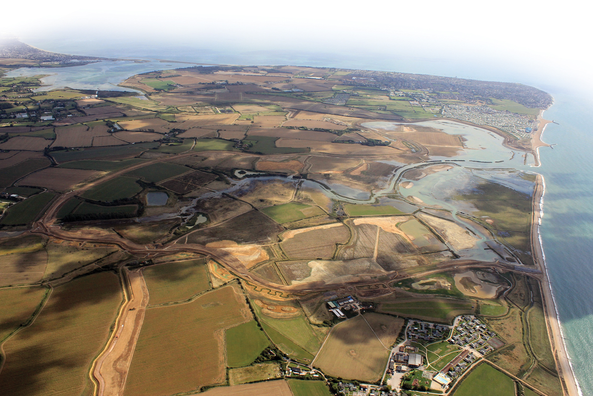
Above: Medmerry immediately after the shingle bar was breached (far right) to allow the sea to flood the intertidal zone.
Site Team
Main contractor: Team Van Oord (Van Oord, Mackley Construction, May Gurney)
Consulting engineer: Jacobs
Marine environmental consultant: ABP Marine Environment Research (ABPMER)
Heritage partner: Archaeology South East (UCL)
Earthmoving contractor: Ovenden
Client: Environment Agency
Giant inflatable bungs temporarily sealed the outfall pipes.
Besides managing the infiltration of seawater into the newly-created intertidal wetland, the Medmerry project has to accommodate the existing natural freshwater flows form the enclosed farmland behind the new earth embankment.
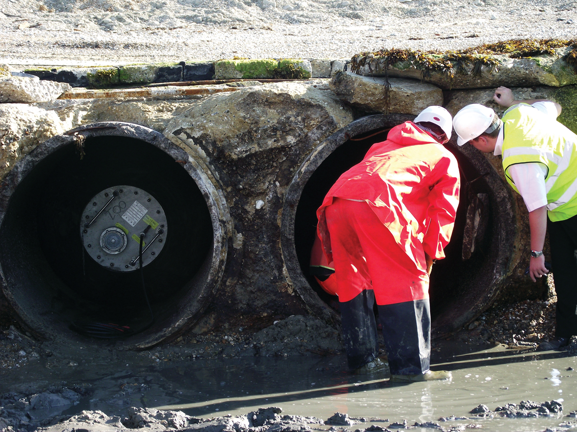
This has been done by digging a new dyke, or “rife” along the inland side of the embankment. This intercepts existing rifes which formerly drained directly into what is now the new habitat on the seaward side. Water collected in this dyke is allowed to drain into the intertidal area through four new outfalls built using precast units designed and supplied by the UK division of Dutch manufacturer Kijlstra.
“Access to each location was difficult and the ground conditions were very soft,” says Kijlstra project manager Stephen Gainsley. “Minimising the amount of work required in-situ helped reduce plant and vehicle movements as well as cutting the number of operatives needed on site,” he says. During installation of the new sluice gates in the outfall headwalls, the 1.2m-diameter culverts were temporarily stopped up with massive inflatable bungs supplied by specialist hire firm Stopper Specialists, part of VP plc.
Got a story? Email news@theconstructionindex.co.uk