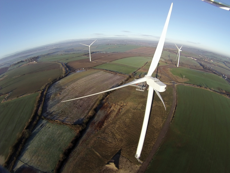
The attraction of using unmanned aerial vehicles – UAVs or drones for short – to inspect inaccessible structures is clear. There’s no need to go to the bother of climbing a ladder, getting hold of a cherry picker, hiring an expensive helicopter or setting up scaffolding. Instead you can stay safely on the ground while the flying robot takes a look for you, using its camera to give you a bird’s eye view and home in on any areas of concern on structures such as wind turbines, chimneys and roofs.
And these days, hobby-level drones are cheap: you can pick one up from your local high street electronics retailer – complete with full pan-tilt camera control, GPS auto-pilot and altitude lock, Wi-Fi connection and full HD video capability - for less than £1,000.
So it’s tempting to whip out your credit card and spend that £1,000 or so, give the instruction manual a quick skim and send the drone aloft – but it’s a temptation that should be resisted. The UK’s Civil Aviation Authority (CAA) is very clear on this: if you intend to use an unmanned aircraft for any kind of commercial activity, you must get its permission to do so or you could face prosecution.
There are, however, plenty of authorized specialist firms around. And some businesses operating in the building and infrastructure sector have found it worthwhile to set up a dedicated drones division to help with their own projects as well as carrying out work for others.
GPS-equipped UAVs can help with an ever-growing range of tasks. Not only can they take high-definition videos and photographs, but they can also help create 3D models or be fitted with thermal and other specialist cameras or sensors to spot hidden problems.
People in the UK wanting to fly a drone as a hobby can operate it under the auspices of the British Model Flying Association – prominent information on the association’s website alerts new purchasers to the law. But you come under CAA requirements as soon as you do commercial work, stresses Gary Clayton, chairman of the Unmanned Aerial Vehicle Systems Association (UAVS), a trade body with a membership that includes companies operating UAVs of all sizes as well as individuals and associated businesses working in areas such as insurance and training. He explains that the CAA issues a company with a licence to operate, in the same way that an airline such as British Airways is a licensed operator with approved procedures that cover, for instance, its use of qualified pilots and its safety and maintenance regimes.
.jpg)
In terms of growth in the small UAV sector, Clayton estimates that there has been a doubling every year in the last three years or so.
Research and development are set to drive the growth still further. Plans for a new £1.25m arena for the next generation of aerial robots were announced in November by Imperial College London.
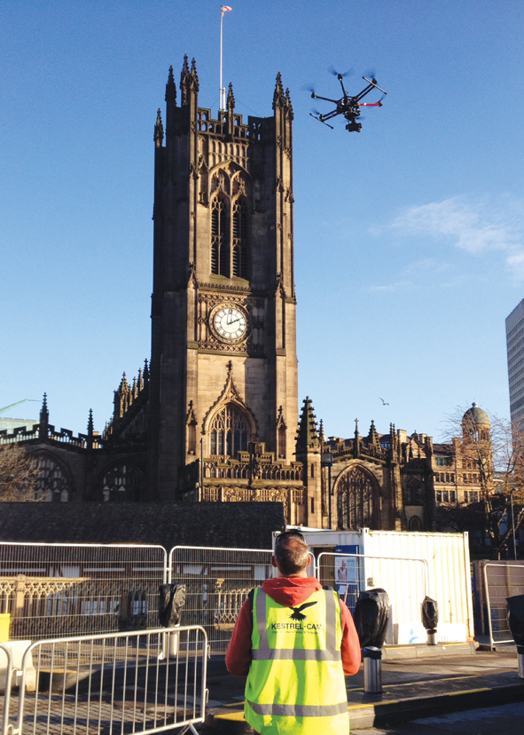
“On the structural side, one of the issues is educating people as to all of the options that UAVs present,” says Duncan Armstrong, flight safety manager of Manchester-based Kestrelcam. But once people have seen a UAV in action they tend to think of plenty of other ways they could make use of it.
One of the company’s recent projects involved concerns about a tall chimney that had been retained as a feature when the factory site it stands on was redeveloped to provide housing. Someone spotted a crack in the wall and it proved much cheaper to send up a UAV than to bring in access equipment or a steeplejack. Thanks to a live feed, the team on the ground was able to look closely at the crack and down inside the chimney, confirming that the damage was only superficial. The client had only thought of using a UAV as he happened to know someone who had already used the service.
Of course UAVs cannot eliminate physical access completely – at least not until flying robots are able to carry out the repairs too. A recent Kestrel-cam project demonstrated savings in access when a leaking roof prompted investigations at all 20 four-storey blocks in a sheltered housing development. The traditional approach would have been to provide scaffolding at all 20 for the inspection but the video of a single day’s flying showed that just five warranted closer investigation – and one of these later turned out to be just a tile stain that resembled a hole. “It doesn’t get away from the fact that sometimes you need a person to get up close,” says Armstrong. “But using the UAV does avoid putting someone up there only to be told that nothing is wrong.” Relaying the images to a screen on the ground enables any additional angles to be taken if required. The footage – which is very stable - is also recorded for later review, typically watched on a big TV screen to allow the video to be seen in detail.
UAVs are also ideal for promotional work and in communicating with local communities. “We are increasingly using drones to photograph our construction sites so we can follow progress,” says David Schofield, project coordinator at United Utilities. “The pictures make a really excellent tool to help explain to neighbours what goes on behind the hoardings.”
A UAV has recently been used to great effect to capture the dramatic operation to lower Gloria, the UK’s largest earth pressure balanced tunnelling machine, into position in Trafford Park as part of a £32m Balfour Beatty project for United Utilities. The scheme is one of six stormwater storage projects being built at an overall cost of about £90m to reduce the frequency of sewer overflows spilling into the Manchester Ship Canal during heavy rainfall.
The main storage shaft is 33m deep and 25m across and the tunnel boring machine is 4m in diameter. The UAV filmed the machine arriving and being lowered into place, ready for Balfour Beatty’s supply chain partner Murphy to start tunnelling under the site. “The sheer size and scale of the scheme is pretty epic so we were very keen to document the key milestones, not just for posterity but also to help inform our local stakeholders about the work we are doing,” says Schofield. “The bird’s eye view that you get with the drone really has the wow factor and the footage looks Hollywood quality – I’m glad to say the budget is much less spectacular!” As well as promotional uses, drones can help identify problem areas. Cambridge Unmanned Aerial Vehicles carries out aerial inspections and is a division of Cambridge (Maintenance Services), which provides buildings maintenance services across the UK. “It means that we understand what we are looking at,” says Alan Perrin, who as well as being one of the pilots at Cambridge UAV is also the firm’s business development manager.
A UAV provides high-resolution time- and date-stamped video recording of an inspection without the complications of scaffolding or other means of working at height, he says. “It’s a much safer way of doing it and much quicker for fragile or difficult-to-reach structures.”
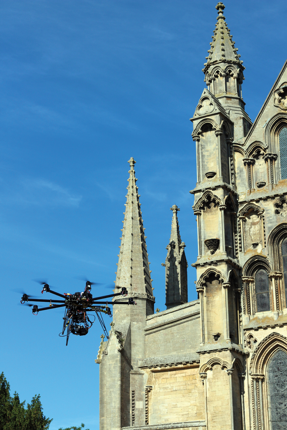
Typical Cambridge UAV projects involve looking at church spires, lighting gantries and large fragile roofs. Perrin found there to be considerable interest in the use of drones when he attended a recent CPD conference for surveyors and engineers but he advises them against simply going out and buying their own UAV. It takes time and money to become qualified and there are ongoing costs including maintenance and training.
“We provide a turnkey service – we cover all of the aviation planning and permissions, qualifications and insurance required to perform an aerial survey,” says Perrin. “At the end of the survey, the client has all of the data and imagery required, without the overheads of aircraft and pilot qualifications.”
Another company that has found it worthwhile to invest in UAVs is urban flood specialist Richard Allitt Associates (RAA). The consultancy only got its first UAV about a year ago but now has a dedicated business, Remote Aerial Surveys (RAS), which already has three qualified pilots and five flying machines carrying equipment including specialist cameras.
RAA principal engineer Martin Allitt – who is also training as a pilot - explains that the company could see benefits in adding value to current projects as well as targeting wider applications. The focus of RAA’s normal work is flood-related engineering and sewerage; clients include the Environment Agency and water companies Severn Trent and Thames Water. The UAVs are seen as particularly helpful in more accurate assessment of the impact of flooding, feeding into the development of schemes to manage flood water better. The decision to explore other sectors too has paid off. Network Rail recently awarded RAS a place on a three-year national framework agreement that will see UAVs used for inspections and surveys of assets such as overhead lines, embankments and structures, both for regular maintenance and after incidents.
One of the big advantages of using a UAV is the rapid turnaround, says Allitt, particularly for infrastructure that is vital for keeping people mobile. The camera’s ability to provide live images means that those who need to inspect a structure can do so without having to go aloft themselves – bringing health and safety advantages too.
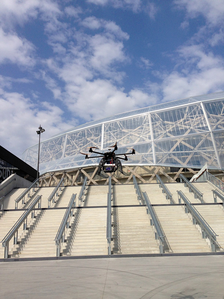
Companies in the Vinci group have started using drones across a range of activities – primarily for video and photography applications, but increasingly as tools for other purposes. For instance, transport infrastructure company Eurovia uses drones to carry out topographic surveys in quarries and measure reserves. Drones equipped with high-definition and thermal imaging cameras help determine the condition of high-rise buildings and perform thermal audits. Vinci Stadium has also been using aerial video capability – to film a rugby match as well as to capture views of a stadium.
Hi-tech kit
.jpg)
There are two principal avenues in the development of UAVs: one is pursuing the smaller type, used for tasks such as structural inspection; the other is developing technologies on a bigger scale to replace the pilot in large aircraft.
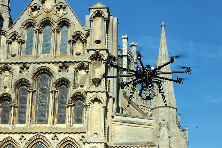
Those in the industry tend to dislike the word drone, favouring UAV or remotely piloted aircraft system (RPAS). The word ‘copter crops up a lot too as a generic term for quadcopters – those spidery machines with four rotors on extended arms – and their bigger brothers, hexacopters and octocopters. Commercial operators tend to use the latter, which have six and eight rotors respectively. Quadcopters can be bought from hobby stores for a few hundred pounds while professional models cost tens of thousands.
Machines in the 7kg to 20kg size range are particularly useful for tasks such as inspections, allowing for a decent battery, a good camera and so on. CAA rules classify the UAV in relation to maximum take-off mass excluding fuel, though most UAVs under 20kg are battery powered.
A typical flight lasts somewhere between 10 and 25 minutes though times are affected by a number of variables including weather conditions and payload. Bigger units are able to take a full-sized digital SLR though mirrorless interchangeable-lens cameras are also popular as they free up valuable weight.
Cambridge UAV always records in HD video, rather than taking still photographs. “Using video gives us a continuous stream of images,” says Alan Perrin. The video can later be reviewed in detail on a large screen. “This allows the end customer and the consultant to freeze the recording on any areas of particular concern and if necessary we can also extract stills for them to have a closer look.”
Kestrel-cam has broadcast-quality cameras for TV productions and uses the same cameras for jobs like roof inspections. The UAV needs to be equipped with a gimbal when using a camera - it enables steady images to be produced, taking out the movement as the craft moves with the wind. The company uses a camera of fixed focal length, as zooming would affect the balance of the gimbal and the image stability. The UAV can readily fly within a metre of a structure. “If I’m looking at something from a metre away, it’s filling the lens and you can see all the detail,” says Duncan Armstrong.
Placing a camera gimbal underneath a drone can make it difficult to get an unobstructed view looking upwards. German manufacturer Height-Tech’s latest model is the HT-8 C180, specifically designed for inspection works in places such as under bridge decks. The HT-8 C180 has its 180° pivotable gimbal in the front. “We see an immense growth in drone use for inspection applications,” says technical sales manager Marius Schröder. “In two to four years these multicopter systems will be a widely used tool.”
More that just a camera
The most obvious uses of UAVs is as a flying camera platform, capturing high-quality conventional still or video images to show progress, plan work, promote a project or look closely at details. Flying can also take place indoors – within a church or the inside of a bridge, for instance.
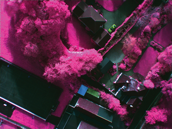
Another use is in photogrammetry, where carefully overlapped pictures capture the features of a landscape from two perspectives and can thus be used to derive measurements and build models. As well as taking photos and videos, the Remote Aerial Surveys business – set up by Richard Allitt Associates - also has equipment that detects the thermal infrared part of the spectrum. Very subtle temperature differences can be picked up - useful for tasks including inspecting power lines as well as identifying issues with building insulation. Applications also include tracking the route of sewers, as wastewater is generally warmer than clean water.
The company has a multi-spectral camera too, which captures the red, green and near-infrared bands. It is particularly useful in urban drainage studies as the processed data can show where there is vegetation and which areas are paved. The images can also show issues such as leaks in buried pipelines, as the vegetation is likely to be more lush above.
Staying on the right side of the law
The moment you use a UAV in a commercial application you need permission from the Civil Aviation Authority. This applies even if no direct charge is being made for the flight: a roofing company’s use of a drone to save the effort of climbing a ladder still counts as a commercial operation.
The operator needs to hold a ‘Permission for Aerial Work’ (PfAW) and it is illegal to carry out commercial work without such a licence. Individual pilots need to hold a qualification issued by a CAA-approved body.
“The regulations are well laid down over here,” says Martin Allitt of Richard Allitt Associates, which has a new UAV business, Remote Aerial Surveys. “It’s all driven from the safety side of things rather than trying to make people’s lives difficult.”
Gaining a PfAW requires the organisation to operate in accordance with aviation and data protection requirements and to use qualified pilots well versed in the safety issues.
Having plenty of insurance cover is also important – after all, a 10kg robot flying at 20mph or more can do a lot of damage if it gets out of control.
However, having permission doesn’t grant unlimited freedom to roam the skies. You can’t go within 50m of vehicles, people or structures unless you have permission from all the right people.
For example, a recent Kestrel-cam job at a house involved liaison with the council and three evenings spent trying to get hold of all the neighbours to check everyone was OK with the idea.
Operating in heavily congested areas requires special permission, and pilots also need to pass an additional test if they are to fly at night.
But there are certainly people running small businesses without permission. They might start out looking at a roof for a friend or taking some promotional shots to help sell a house; further assignments follow by word of mouth. “Despite our efforts to get the word out that the CAA regulates this activity, there are many operators operating outside the law,” says UAVS chairman Gary Clayton. “This is a result of their not knowing rather than any deliberate act.” It is not only the commercial drones that are attracting attention. Air traffic control service NATS has been speaking out about dangers now that more people are buying a system for fun. Most incidents have related to use near military sites or at public events but NATS is particularly alarmed by reports of flights near manned aircraft. In April, a man from Cumbria became the first person in the UK to be successfully prosecuted for the dangerous and illegal flying of an unmanned aircraft – he was fined £800 and the CAA was awarded costs of £3,500.
Businesses have to operate in accordance with the Data Protection Act as well as CAA procedures. There is currently debate in Europe about whether new laws are needed to deal with situations where the UAV’s camera breaches someone’s right to remain anonymous.
Staying safe
An advantage of UAVs is that they can give you a close-up view of places that are difficult to reach, while avoiding the health and safety issues associated with people working at height.
Inaccessible places are not confined to high structures or confined areas behind buildings. UAVs are also ideal for showing the extent of flooding or giving a rapid overview of the banks of a river.
Deployment can be spontaneous, rapid and flexible, allowing developing problems to be closely monitored. For safety reasons, professional operators generally use a two-person operation, allowing one to concentrate on flying the craft and the other to point the camera. “If you are looking at the screen to see where the camera is pointing then you are not looking at the craft – which obviously isn’t safe,” says Kestrel-cam's Duncan Armstrong. Also, clients tend to want to chat – better to talk to the camera operator than to distract the pilot.
Despite the need to consider everything that could possibly go wrong, he stresses that the sector’s safety record is superb. “When they do crash it is normally down to human error,” he says. The person might not have checked the battery level, or have flown too close, or in unsuitable weather. An eight-rotor model will still generally be able to fly safely even if two motors fail. The more sophisticated models are also equipped with fail-safe systems – for example, should one lose its signal it will climb to a preset height and fly back to where it originally took off. Once locked into the GPS, Kestrelcam’s biggest craft stays stable within a virtual box measuring about a cubic foot, says Armstrong. A smaller quadcopter may move more and so would need to be kept further away from a structure. The smaller machines are also more limited to use in lower wind speeds of about 10mph rather than the 20mph or so for bigger units.
This article first appeared in the December/January 2015 issue of The Construction Index magazine. To read the full magazine online, click here.
To receive you own hard copy each month in traditional paper format, you can subscribe at
http://www.theconstructionindex.co.uk/magazine#
Got a story? Email news@theconstructionindex.co.uk