
The contracting joint venture is working on behalf of the Highways Agency to improve the M1 between junctions 10 and 13.
Aerial photography has enabled the team to highlight potential problems much faster and in far greater detail than traditionally manned aerial photography, they say.
The Swiss-made SwingletCAM device is a ready-to-deploy micro aircraft with an 80cm wingspan and a built-in high resolution camera. Powered by a rechargeable lithium-polymer battery, the craft has an on-board GPS and flight plan set via computer. It weighs less than 500g – light enough to be launched by hand. It can land autonomously on any surface without a parachute or landing net.

The artificial intelligence incorporated in the SenseFLY autopilot continuously analyses data from an inertial measurement unit and, from the on-board GPS, takes care of all aspects of the flight process. The flight plan can be pre-programmed in the project office and then launched from a pre-determined position. Users can alter the trajectory of the device during flight with a simple drag and drop on the computer. Additionally, it can be used for 3D photogrammetry surveys and can be overlaid onto maps such as Google Earth.
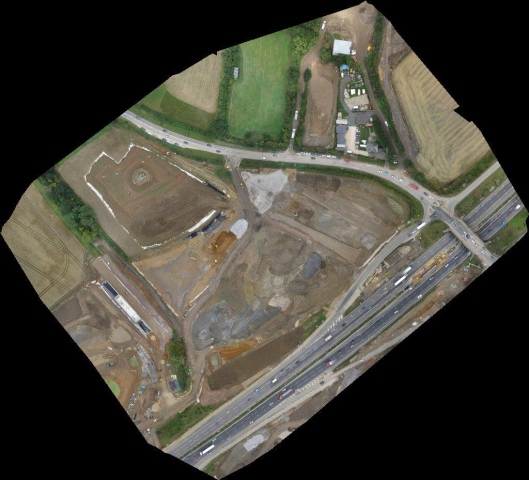
Stuart Fagg, a land and engineering survey manager for the Costain Carillion JV, said SwingletCAM took just five minutes to photograph the entire works on junction 12. The photographs were available immediately after landing and the photos were then stitched together to provide an overall view of the works with 100% coverage.
“We’ve just trialled SwingletCAM and the potential to transform and improve our planning, recording and tracking procedures is very exciting. It can be deployed in a matter of minutes and delivers instant results which, on a wide range of projects, could prove invaluable. It’s a safe system, significantly more environmentally friendly and more cost effective in comparison to traditional methods of aerial photography. The high quality of the images along with the positional information gathered means we can obtain a far greater knowledge of the site than we do from traditional aerial photos,” Mr Fagg said Stuart.
Got a story? Email news@theconstructionindex.co.uk

